Norna Sinclair: Stromness 12/03
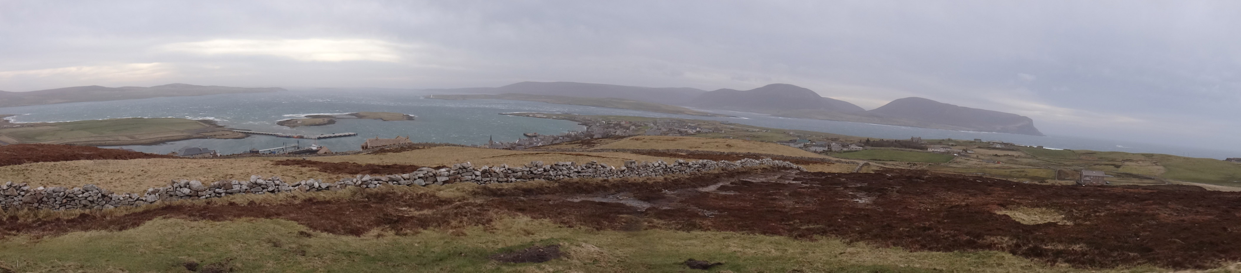
A VERY windy start to the day and an invigorating walk to the viewpoint on top of Brinkies Brae, looking over Stromness to Hoy.
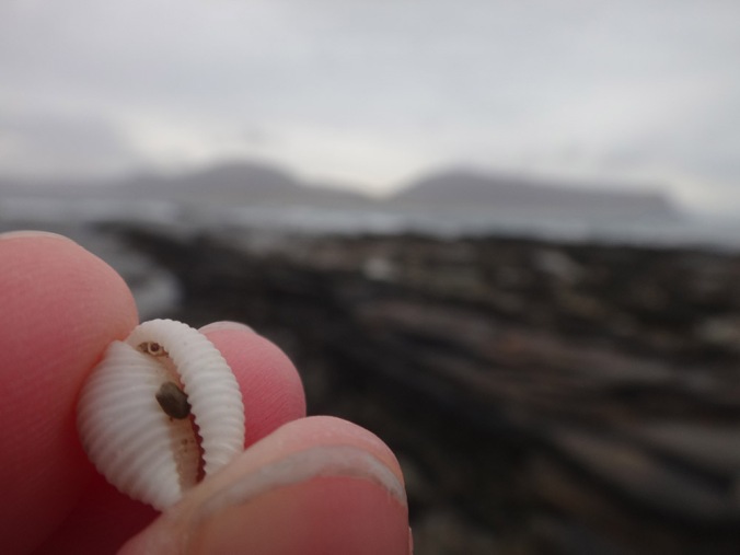
Continuing on round the west shore and my special groatie buckie beach (small cowrie shell, the finding of which brings good luck!).


Then on past the Point ‘o’ Ness and through Stromness!
Later a quick ‘nip tae the toon’ via Waulkmill Bay, Orphir.
Neil Ackerman: Kirkwall 12/03
A walk around Kirkwall …


A day of meandering with my son, trying to keep us both amused and stop him running riot in the house. An initial walk through the Willows to see the crows then into the shelter of the garden centre to see the budgies. After this we wondered through town picking up a mother’s day card and few bits and bobs from the shops, through the town centre then home. After lunch, and a nap for the wee one, we braved the weather to post the mother’s day card down to Edinburgh, then a wonder around the harbour then round the Peedie Sea. The weather was enough to give even the Peedie Sea some pretty impressive waves, so we retreated for an adventure into the great known that is jungle world. After dealing with the weather, some familiar smiling cartoon lions in a nice warm soft room was very welcome. A dash home with the buggy zipped up concluded our adventure, a tired dad and son happy to be have a hot dinner and get ready for bed to face another day.

Listen to the wind and rooks in the trees
Beth Murray: Kirkwall to Herston 14/03

I started out in St Ola and headed into the town and up to the college. A lot of the day was spent in and around the college but there was a rather exciting jaunt out. We headed out to Herston in South Ronaldsay to look at what was left of the Monarch (Canmore ID: 101994) as well as to do a preliminary survey of some of the smaller derelict boats on the foreshore as part of the NAS course in Foreshore and Underwater Archaeology. There’s plenty of activity on the beach and up the grass verge as I moved around the boat and to collect pieces of equipment. Herston is also great for sea glass and I managed to collect a piece or two of pottery too! After a trip back to the college it was time for home (and an early night) but first I stopped by the harbour to admire the lovely sunset.

Jenny Campbell: Eday 14/03


I chose this day to map Eday as it was my last full day living here, after two and a half years working as ranger and a bird surveyor on the island; I was leaving the following day. It was also my final event as Eday ranger, as part of British Science Week, together with Eday Heritage Centre, we had organised ‘Lichenopolis, the weird and wonderful world of Lichen’. My first trip of the day was from where I live in the north end, Calfsound, to pick up our guest for the day, at the pier. Julian Branscombe from RSPB came along to give us a talk on Lichen for beginners and help us identify some ‘in the field’; the ‘field’ being the old Kirkyard at Skaill a few miles south of the Heritage Centre (itself an old Baptist church).


Back to the Heritage Centre in the afternoon for sausage, egg and chip lunch then a few afternoon activities involving lichen quizzes, microscopes, oldest lichen competition and dyeing wool using lichens!
It was a bit windy but sunny and a fair few folk turned out to join in and learn a bit about Eday’s lichens as well as say goodbye, so it was a really lovely way to spend my last day on Eday.
Alan Craigie: Hoxa Head 15/03
A walk from St Margret’s Hope around Hoxa Head and back.


Rowena Baker: Kirkwall Bay 15/03
My mapping day started with feeding the hens and helping my daughter revise for her National 5’s. We both then went to Hatson slip for rowing practice with the Orkney Rowing Club, rowing a traditional Fair Isle Yoal and getting a Viking eye view of the Orkney Landscape.

Afterwards, back home and more revision followed by a walk down the field to the shore from where we can see the buoy marking the site of the Royal Oak (sunk by a u-boat in WWII ).

While walking along the shore and within sight of the Royal Oak buoy I found part of a poppy wreath that may have been laid down on 14th October to commemorate the loss of 883 young lives.


Stromness Community Garden: mapping workshop 15/03 
We mapped the garden (plots, paths, drain, shed, car park & polytunnel) to create an accurate plan.
Black = Garmin handheld GPS x 2 (5m accuracy)
Red = Lecia Viva GNSS (15mm accuracy)
Tonje Birkeland: Bergen // Hoy 15/03

Gulfjellstoppen, Bergen, Norway
60°38’75.3″N 5°59’04.8″W

Ward Hill, Hoy, Orkney
58°54’23.1″N 3°20’10.5″W
I imagine it possible to stand on one of these mountains, both of them the tallest mountain, the peak of the specific piece of land surrounding it.
Both mountains may be covered in mist or clouds, the wind may hit them over and over again. Yet, this particular day in March, the sun shines at Gulfjellet. I imagine the skies being blue all the way to Hoy, as if I may see that mountain if I just gaze long enough in the exact right direction.
Luelle stood on both of these mountains. While standing on one of the peaks; did she long for the other?
III. White Hares of Ward Hill
White shirt clings chest in spirals, as the solid black valleys surround the scene.
Wild wind, whirling in salty waves, fifteen thousand feet above wave and water.
Wild hares with white winter fur, running wild on black land,
emerge as evidence of earlier human presence, easy to forget.
White shirt, whirling wind and wild hares: Ward Hill on the island Hoy.
Luelle Magdalon Lumiére, Hoy, February 1901.
LUELLE MAGDALON LUMIÉRE (1873-1973)
Luelle Magdalon Lumiére, stereo photographer, reaches the peak of her career around 1913. Luelle is a restless, yet strong woman that never settles. In her earlier years she wanders among the mountains of western Norway. Later she gets aboard a ship and travels west to the enormous urbanity of New York, the frontiers of Brooklyn and the boardwalks of Coney Island. One day she leaves to travel back north, first here, to Papa Westray, Orkney – travelling forth, driven by mystery, illusion and magic, from one island, one independent reality, to the next.
Rosey Priestman & Brendan Colvert: Stove, Sanday 13/03
Re-forming the Stove Pearl … 
Due to a GPS technical hitch, the Stove Pearl was re-mapped on 13/03. What a beautiful map!
The map so far:


Pingback: Map Orkney Month Week 4: Winding the clock, drawing Stromness and imaginary journeys from elsewhere | Public Archaeology 2015
Reblogged this on Archaeologists in Residence.